Travel Victoria
Regions
All regions
Melbourne & Suburbs
Daylesford & Macedon Ranges
Geelong & The Bellarine
Gippsland
Goldfields
Grampians
Great Ocean Road
High Country
Mornington Peninsula
Murray
Phillip Island
Yarra Valley & Dandenong Ranges
Cities & towns
All cities & towns
Aireys Inlet
Albert Park
Alexandra
Anakie
Anglesea
Apollo Bay
Ararat
Arthurs Seat
Avoca
Bacchus Marsh
Bairnsdale
Ballarat
Balnarring
Barnawartha
Barwon Heads
Beaufort
Beaumaris
Beechworth
Belgrave
Benalla
Bendigo
Berwick
Blackwood
Blairgowrie
Bright
Brighton
Broadford
Brunswick
Bruthen
Camperdown
Cape Otway
Cape Schanck
Cape Woolamai
Carlton
Castlemaine
Charlton
Chelsea
Chiltern
Clifton Springs
Clunes
Cobram
Cockatoo
Cohuna
Colac
Corinella
Corryong
Cowes
Cranbourne
Creswick
Croydon
Dandenong
Daylesford
Dimboola
Docklands
Donald
Dromana
Drouin
Dunkeld
East Melbourne
Echuca
Eildon
Elwood
Emerald
Euroa
Fitzroy
Flinders
Foster
Frankston
Geelong
Golden Beach
Grantville
Halls Gap
Hamilton
Hampton
Harrietville
Hastings
Healesville
Heathcote
Hepburn Springs
Horsham
Inverloch
Jamieson
Kallista
Kalorama
Kaniva
Kerang
Kilcunda
Kilmore
Korumburra
Kyneton
Lake Bolac
Lakes Entrance
Lavers Hill
Leongatha
Lilydale
Lorne
Macedon
Maldon
Mallacoota
Mansfield
Marlo
Maryborough
Marysville
Melbourne CBD
Merrijig
Metung
Milawa
Mildura
Mirboo North
Moe
Montrose
Moonee Ponds
Mornington
Morwell
Mount Beauty
Mount Dandenong
Mount Eliza
Mount Macedon
Mount Martha
Myrtleford
Nagambie
Natimuk
Neerim South
Nelson
Newhaven
Nhill
Noojee
North Melbourne
Ocean Grove
Olinda
Omeo
Orbost
Ouyen
Parkville
Paynesville
Point Lonsdale
Porepunkah
Port Albert
Portarlington
Port Campbell
Port Fairy
Portland
Port Melbourne
Portsea
Port Welshpool
Queenscliff
Red Hill
Rhyll
Richmond
Robinvale
Rosebud
Rutherglen
Rye
Safety Beach
Sale
Sandringham
Sandy Point
San Remo
Sassafras
Seaford
Seaspray
Seymour
Shepparton
Smiths Beach
Sorrento
Southbank
South Melbourne
South Yarra
St Arnaud
Stawell
St Kilda
St Leonards
Surf Beach
Swan Hill
Talbot
Tarwin Lower
Tooradin
Torquay
Traralgon
Venus Bay
Walhalla
Walkerville
Wandiligong
Wangaratta
Waratah Bay
Warburton
Warracknabeal
Warragul
Warrnambool
Werribee
Williamstown
Wodonga
Wonthaggi
Woodend
Wye River
Yackandandah
Yanakie
Yarra Glen
Yarragon
Yarram
Yarrawonga
Yea
Accommodation
Experiences
About Victoria
Home
Regions
Grampians
Stawell
Photos
Stawell
- photos
Stawell
Introduction
Stay
Accommodation
See and do
Attractions
Tours & adventures
Sport & recreation
Events & festivals
Food and drink
Restaurants, cafes & bars
Fast food & takeaway chains
Shopping
Supermarkets
Getting around
Public transport
Car hire
Petrol stations
Maps & location
Visitor information
Visitor services
Facts & features
Weather & climate
Photos
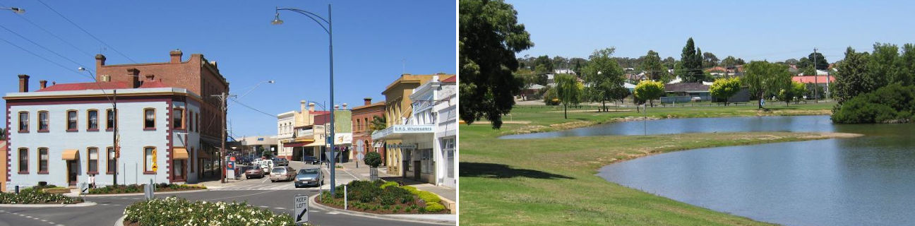
Commercial centre - view south-west along Main St at Layzell St
Commercial centre - view south-west along Main St between Victoria Pl and Wimmera St
Commercial centre - view south-west along Main St between Victoria Pl and Wimmera St
Commercial centre - view north-east along Main St between Victoria Pl and Wimmera St
Commercial centre - view north-east along Main St at Wimmera St
Commercial centre - Stawell Post Office, corner Wimmera St and Main St
Commercial centre - Town Hall, Main St at Wimmera St
Commercial centre - Anglican Church, corner Main St and Manse St
Central Park - main grandstand
Central Park - main grandstand
Central Park - gardens behind main grandstand
Cato Park - entrance
Cato Park - view east across lake towards Sloane St
Cato Park - view north across lake towards Florence St and Town Hall
Big Hill Lookout - memorial
Big Hill Lookout - view south
Big Hill Lookout - view south-west
Big Hill Lookout - view west to commercial centre and town hall
Big Hill Lookout - view east across dams
Court House - Patrick St
View north-east along Seaby St towards railway line
Old Pleasant Creek Court House, Western Highway between Griffith St and Seaby St
Sisters Rocks, Western Highway
Sisters Rocks, Western Highway
Lake Lonsdale - access road and car park, north side of lake
Lake Lonsdale - windmill near car park, north side of lake
Lake Lonsdale - view south-west across north side of lake towards The Grampians
Dadswells Bridge - Giant Koala