Walkerville
Walkerville
Stay
See and do
Food and drink
Shopping
Getting around
Visitor information
Walkerville is a small community located along the western coastline of Waratah Bay and a short drive from the neighbouring coastal towns of Waratah Bay and Sandy Point. It is a comfortable drive from Wilsons Promontory National Park and surrounding attractions.
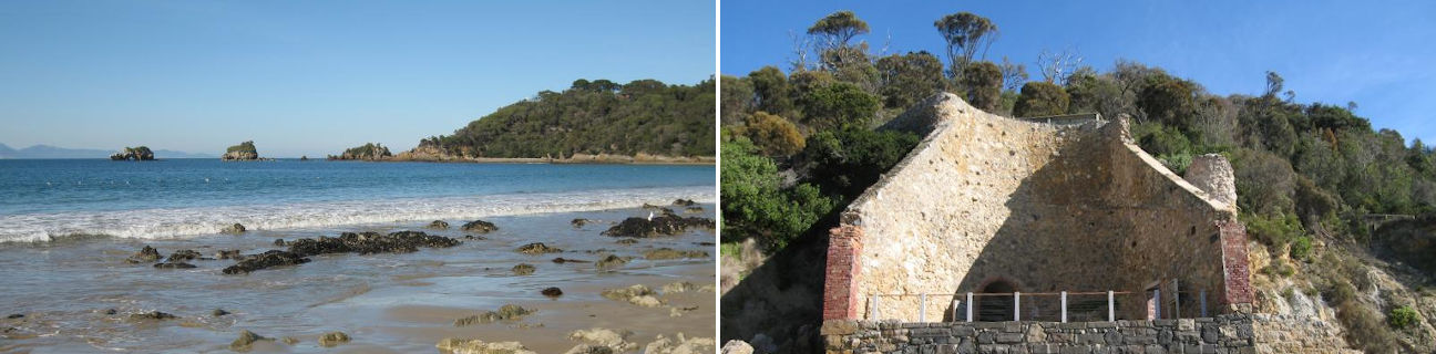
The approach to Walkerville from the north via the Fish Creek Road passes through lush and undulating pastoral land and ends up at the Promontory View housing estate. At this point, following the no through Bayside Drive along the coast for a couple of kilometres takes visitors past the local caravan park and to Walkerville North. Alternatively, the inland route makes an almost 10 kilometre semi-circle around this section of the Cape Liptrap Coastal Park, rejoining the coast at Walkerville South and then terminating part way along the coast at the boat ramp. The two dead-end coastal roads at Walkerville North and Walkerville South are linked by an 800 metre walking track called the Limeburners Walk which traverses the cliff tops and offers spectacular views along the pristine coastline. Alternatively, walking between the two road endpoints can be done along the sandy beach with its characteristic rock formations and native bush backdrop.
The limestone cliffs around Walkerville were actively mined until 1926, supplying material for Melbourne's building industry. A relic of the lime burning process can be found along the foreshore between Walkerville North and South at one of the kilns which has been preserved.
Despite having few local services, Walkerville has developed into a destination for those seeking a quiet, relaxing day trip or holiday. There are good views of the mountain ranges at Wilsons Promontory from the safe swimming beaches and scenic fishing spots which front Waratah Bay and there are several interesting rock formations just off the coast, including Arch Rock and Bird Rock.
Around 10 kilometres south-west of Walkerville, along a gravel road, is Cape Liptrap. At the cape is a 10 metre high lighthouse which was built in 1951 and offers picnic areas and scenic views along the surrounding coastline.