Warracknabeal
Warracknabeal
Stay
See and do
Food and drink
Shopping
Getting around
Visitor information
The town of Warracknabeal is situated between Horsham and Hopetoun in the north-west of the state.
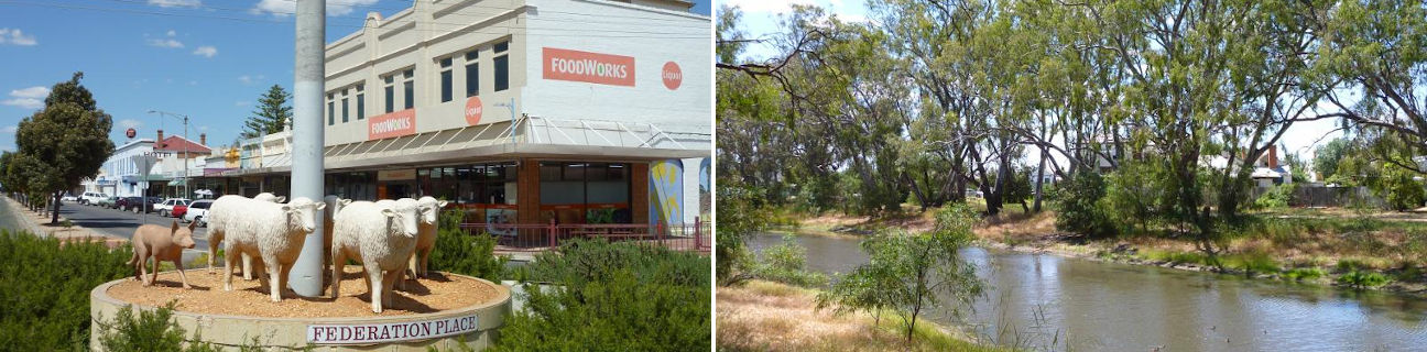
Warracknabeal's commercial centre can be found along the northern end of Scott Street. It features a number of historic buildings including the Tudor-style post office (built in 1907) and the old State Savings Bank building (1909) which now houses the Warracknabeal Historical Centre which has displays open to the public. The junction of Scott Street and Woolcock Street is known as Federation Place and full-size sculptures of sheep and a kelpie dog are located within the roundabout as a tribute to the town's early settlement days. Another historic tribute can be found within the roundabout at the junction of Phillips Street where a sculpture of a dog sits atop bags of wool.
Other historic buildings within Warracknabeal include the court house in Woolcock Street which was built in 1891 and is now used by the Warracknabeal Historical Society. A log lock-up, which was built in 1872 and used by the police, can be found in Devereux Street. The Anglican Church on the corner of Lyle Street and Anderson Street dates back to 1887, and an old brick water tower, which was used to service stream trains and later for the town's drinking water, was built in 1886 and can be found at the northern end of Tarrant Street.
Anzac Park is the recreational centre of Warracknabeal. Located at the junction of Scott Street and Arnold Street, there's a memorial grandstand, a sports oval, tennis courts and pool.
The attractive Yarriambiack Creek flows through Warracknabeal, lined with river gums and populated with water birds. It swells in width north of Lyle Street where a number of parks and gardens can be found on both sides of the waterway. There are several footbridges across the creek and a boat ramp off Craig Avenue. A flora and fauna park is located on a sweeping bend of the creek at the northern end of Scott Street and it includes BBQ and picnic areas, a playground and native animals housed in large enclosures. The Yarriambiack Creek Walk consists of tracks along both sides of the river which take in some interesting sights along the way.
The prosperity that Warracknabeal is now enjoying is the result of its diverse agricultural industries which include fat lambs, wool, wheat, barley, lupins and canola.