Marysville
Marysville
Stay
See and do
Food and drink
Shopping
Getting around
Visitor information
Marysville is located within the heavily forested mountains of the Great Dividing Range, a short drive off the Maroondah Highway between Healesville and Alexandra.
Due to its scenic and peaceful location, Marysville has long been a popular holiday retreat for visitors, especially during the spectacular springtime blooming season and the colourful autumn period. Its history dates back to the mid-1800s when gold was discovered in the area, however it wasn't long before guest houses were established and the town became a favourite for honeymooners due to its tranquil setting amongst native bush and waterfalls.
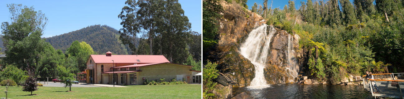
Marysville is situated on the Steavenson River, which runs through the town centre and is lined by parks and gardens. The river runs through Gallipoli Park, which features beautifully landscaped gardens, BBQs, shelters, a lake with fishing platforms, an historic water wheel, extensive playgrounds, a sports oval, community centre and walking tracks.
The town centre of Marysville extends along the shady avenue of Murchison Street which has been landscaped to reflect the surrounding natural environment. Street gutters along one side of the road have been replaced by a meandering rocky stream lined with native grasses featuring bridges leading to shop doorways. The town's supermarket is situated within parkland beside the Steavenson River in neighbouring Darwin Street.
3 kilometres south-east of the town centre along Falls Road is Steavenson Falls. They are one of Victoria's highest waterfalls with a drop of around 84 metres. A flat and well-formed 350 metre long track leads from the car park to the falls where there are several viewing platforms. The falls are floodlit from dusk until 11pm each night, powered by a hydroelectric turbine.
Marysville is an ideal area for bushwalking, with many tracks through the surrounding forests having originally been timber tramways which were used to haul logs to local timber mills. Keppels Lookout, accessed by driving along Paradise Plains Road or via a walking track from either the town centre or Steavenson Falls, offers stunning views of the landscape and forests surrounding Marysville. Good views can also be enjoyed from the top of Mount Gordon Road which is accessed from the road between Marysville and Narbethong.
An interesting tourist drive is along Lady Talbot Drive which is accessed via Woods Point Road just east of town. Attractions along this route include the Phantom Falls, Keppel Falls, Taggerty Cascades and The Beeches Rainforest Walk which is a scenic 4 kilometre circuit through ancient rainforests with many trees over 300 years old.
Around 25 minutes drive east of Marysville is Lake Mountain which rises to a height of 1,433 metres and offers fantastic views of the Victorian Alps. During the snow season, the mountain offers visitors cross country skiing, while at other times of the year bushwalking along the scenic ski trails is a popular activity.
The village of Buxton, 11 kilometres north of Marysville is set along the Steavenson River and at the southern tip of the Cathedral Range State Park with its huge rocky peak. Buxton includes a hotel, general store, an attractive park along the river and a trout and salmon farm.