Halls Gap
Halls Gap
Stay
See and do
Food and drink
Shopping
Getting around
Visitor information
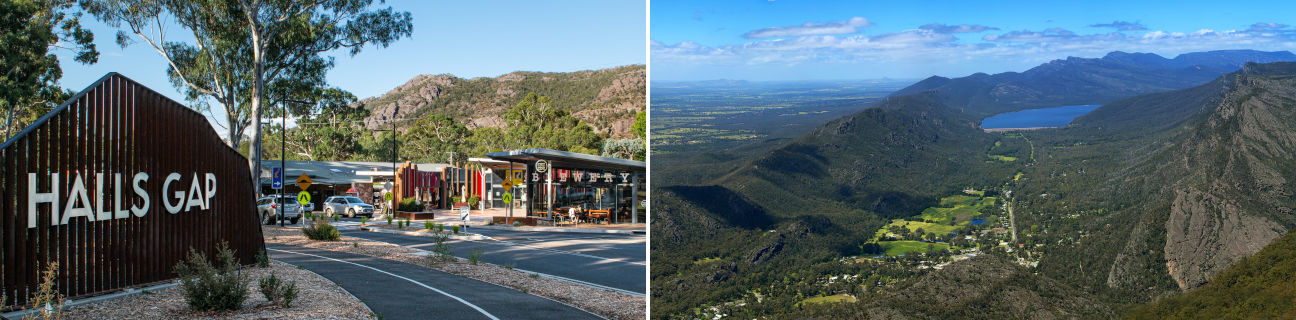
The small township of Halls Gap is located in the heart of the Grampians National Park and within easy driving distance of the larger centres of Stawell and Ararat.
The Halls Gap town centre is nestled between the soaring rocky mountain peaks that constitute the Wonderland and Mount William Ranges. A number of cafes and tourist shops can be found facing the grassy areas fronting Stony Creek, while the attractive Halls Gap Picnic Reserve is just across the road from the rest of the commercial centre.
The Grampians are one of Victoria's most impressive natural attractions, popular with bushwalkers and holidaymakers seeking a mountain forest and lake environment. The Grampians span the western end of Victoria's Great Dividing Range, which consists of soaring mountain peaks, rugged and lush bushland, rivers, waterfalls, and a number of large lakes. The Grampians National Park covers 167,000 hectares and is home to hundreds of species of native animal life. Spring time sees the area covered in colourful wildflowers, celebrated by the annual Halls Gap Wildflower & Art Show, while waterfalls flow at their peak at this time of year. A myriad of walking tracks exist in the area, many leading to spectacular lookouts over the park and surrounding ranges. Lake Bellfield, just a few kilometres south of Halls Gap, offers picnic areas, swimming and boating activities.
A scenic drive north-west of Halls Gap along the road towards Horsham encompasses some interesting attractions.
A detour via Mount Difficult Road leads to the Boroka Lookout where spectacular views over the Halls Gap town centre and south to Lake Bellfield can be enjoyed. Further along on the Mount Victory Road is the Reed Lookout with its views across an endless expanse of dense bushland and of Lake Wartook and the Moora Moora Reservoir.
A brief detour via the Wartook Road leads to the largest waterfall in the Grampians - the MacKenzie Falls. Kiosk and picnic facilities are located next to the car park and a walking track leads to the Broken Falls and a lookout above the MacKenzie Falls. Visitors can descend the track down to the rockpool at the base of the falls.
The Wartook Road ends at Lake Wartook which is a major supplier of water for surrounding towns and is surrounded by mountains.
The main road north-west towards Horsham passes through the Zumstein Picnic Area which was originally a tourist park in the early 1900s but now offers picnic and BBQ facilities and a popular spot to view kangaroos and other wildlife.
At the north-western edge of the Grampians National Park is the Wartook Valley. Surrounded by panoramic views of the Grampians, this area comes alive during springtime with rich and colourful wildflower displays. Other attractions in the valley include abundant wildlife, several walking and 4WD tracks, Aboriginal art sites and relics of European pioneering history.
The Serra Range extends to the most southerly part of the Grampians National Park and includes the iconic peaks of Mount Abrupt and Mount Sturgeon. The small town of Dunkeld sits just outside the national park at the base of those mountains.