Current conditions
Weather
Transport
Driving
Types of roads
Toll roads
Tunnels
Bridges
Traffic reports
Road rules
Driving in snow
Driving safety
Fuel
Electric car charging
Food quarantine rules
Location & maps
Facts & figures
Communications
Holidays
Visitor information
Your safety
Government
Rainfall radar
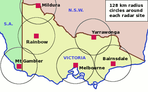
| Radar location | 64 km view | 128 km view | 256 km view | 512 km view |
|---|---|---|---|---|
| Melbourne | ||||
| Bairnsdale | ||||
| Yarrawonga | ||||
| Mildura | ||||
| Rainbow | ||||
| Mt Gambier (S.A.) |
Satellite images
Latest satellite image for Victoria »
The day/night images are effectively a photographic snapshot with thick cloud showing up as bright white objects and thin cloud as paler shades of grey. Warmer low cloud and fog, which may not be detected by infrared, will show up in this snapshot. Thin high cloud is usually better detected in the infrared image.
The infrared satellite images are derived from the temperature of the sky. It depicts higher and colder clouds in an increasing bright white colour, while warmer low cloud will show up in darker shades of grey. Cloud that is close to the ground or fog may not show up in these snapshots. Images are available 24 hours a day.
Other current conditions
Latest Melbourne observations »